|
| |
| |
| |
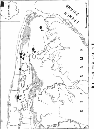
Fig. 1. Map of Northeast Suriname showing the distribution of archaeological sites belonging to the Barbakoeba complex. Legend: (1) settlement sites of the Barbakoeba complex; (2) mud flats; (3) naturally-formed sand bars or cheniers; (4) boundary of the Suriname coastal plain; (5) rivers and creeks. Key to sites: (1) Parmarica Creek-1 (SUR-31); (2) Parmarica Creek-2 (SUR-92); (3) Oranje Creek/Cordonpad (SUR-95); (4) Barbakoeba Creek-2 (SUR-30); (5) Barbakoeba Creek-1 (SUR-29); (6) Boekoe Creek-2 (SUR-347); (7) Wane Creek (SUR-322).
| |
| |
| |
Arie Boomert
The Barbakoeba Archaeological Complex of Northeast Suriname
Recent archaeological research has shown that the first horticultural, pottery-making Amerindians entered the coastal zone of the Guianas in the latter half of the first millennium BC. A number of local cultural complexes can be distinguished, most of which are to be grouped into three major, subsequent ceramic traditions. The first and second of these regional pre-Columbian cultures, the Saladoid and Arauquinoid series, respectively, are western in origin, ultimately deriving from the middle and lower portions of the Orinoco Valley in Venezuela. In contrast, the inception of the third and final prehistoric Amerindian culture of the Guianas, the Marajoaroid series, has to be sought in the southeast, the Amazon Basin. This paper discusses the characteristics and affiliations of an important local cultural tradition of the Arauquinoid series in Suriname, the Barbakoeba complex. According to criteria of pottery style and calibrated (cal) radiocarbon dates, this cultural assemblage of the eastern part of Suriname's coastal plain can be placed between about cal AD 650 and 1250.
| |
Sites and ridged fields
Archaeological sites belonging to the Barbakoeba complex are to be found exclusively between the Commewijne and Maroni (Marowijne) Rivers of Northeast Suriname, north of the Cottica River and the Wane Creek (Fig. 1). Six sites are known, all representing former Indian settlements. In addition, extensive complexes of so-called pre-Columbian ridged fields, i.e. artificially raised horticultural beds, and other earth structures are to be found in this part of the Suriname coastal zone. In prehistoric times these raised fields provided well-drained floors for cultivation throughout the year. Most likely they are associated with the settlement sites of the Barbakoeba Amerindians. All Barbakoeba sites are situated on chenier ridges, i.e. naturally formed, elongated sand bars, surrounded by vast areas of permanently or periodically inundated freshwater grass swamps and marshes. Such cheniers are to be found in the entire Coastal Plain of the Guianas and the Orinoco Delta, grouped in bundles stretching parallel to the Atlantic shore. These forested ridges represent the only natural features in this marsh-and-swamp landscape which are situated at an elevation, sufficiently high to escape flooding in the wet season. Consequently, they provided the most suitable places of habitation in prehistoric times, as they still do at present.
Five sites of the Barbakoeba complex are situated on the same narrow bundle of sandy chenier ridges in this portion of Suriname's Young Coastal Plain or Demerara Formation. They include, from west to east, firstly, the Parmarica-1 (SUR-31) and Parmarica-2 (SUR-92) sites, both to be found near the Parmarica Creek in the Commewijne District, secondly, the Oranje Creek/Cordonpad (SUR-95) site, situated just east of the Mot Creek in the Marowijne District, and, finally, the Barbakoeba Creek-1 (SUR-29) and Barbakoeba Creek-2 (SUR-30) sites, i.e. the type sites of the complex, to be found north of a tributary of the Barbakoeba Creek in the Marowijne District
| |
| |
(Fig. 2). The Oranje Creek/Cordon pad and the two Barbakoeba Creek sites are associated with complexes of pre-Columbian ridged fields. Moreover, two settlement sites of the Barbakoeba complex have been discovered further south in the Marowijne District. They include Boekoe Creek-2 (SUR-347), situated just south of the Cassipera Creek, and Wane Creek (SUR-322), to be found close to a seasonal tributary of the stream of this name. Both sites occupy sandy ridges belonging to Suriname's Old Coastal Plain or Coropina Formation. They are situated near extensive complexes of pre-Columbian ridged fields. All sites of the Barbakoeba complex are terra pretas in Amazonian sense, consisting of an uninterrupted habitation layer of black earth which measures some 30 to 40 cm in thickness at the Wane Creek and Barbakoeba Creek-2 sites. The sites of the Barbakoeba complex conform closely to the model of a prehistoric Amerindian chenier settlement in the middle of a ridged field area, developed by the author (see Boomert 1975, 1978).
The Boekoe Creek-2 site represents the first known site of the Barbakoeba complex as it was visited by Peter R. Goethals as early as June/August 1951 (Goethals 1953: 46). The Parmarica Creek-1 site was investigated by Dirk C. Geijskes and Piet Bolwerk of the Suriname Museum, Paramaribo, in May 1961. It yielded an important collection of pottery and stone artifacts which remained unpublished until at present. Subsequently, in March 1964 Lieutenant H.J. Neve discovered the Oranje Creek/Cordonpad and Barbakoeba Creek-2 sites during a patrol by the former Dutch Expeditionary Force in Suriname (TRIS). He made a small collection of finds on both locations. The Parmarica Creek-2 site was first encountered by Frits Kruizinga of the Suriname Department of Soil Survey in July 1972. Next, Frans C. Bubberman and Joost J. Janssen discovered the Barbakoeba Creek-1 site and revisited Barbakoeba Creek-2 in December 1973, collecting a substantial amount of pottery, discussed in this paper, at both sites. The Wane Creek site was discovered by Janssen during exploration drillings by the Suriname Aluminum Company (SURALCO) in December 1974 (Janssen 1974). Finally, Boekoe Creek-2 was visited in July 1975 by Bubberman and Janssen who made a substantial surface collection of pottery on this location. It was subsequently investigated by Aad H. Versteeg during an expedition in April 1976 (Bubberman 1976). Only the material recovered on the latter occasion was not available for study to the author.
Complexes of artificially raised fields are known from the eastern portion of Suriname's coastal zone since 1939 (Boomert 1975, 1978). Studies of air photos by Zonneveld, Bubberman and the author showed that the pre-Columbian ridged field systems of this region form vast areas, running parallel to the local bundles of coastal sand bars. They are typically constructed adjoining the southern edges of the cheniers belonging to the Demerara Formation, sloping into the marshes and swamps (Fig. 2). Most fields are rectangular to squarish in shape and arranged in geometric patterns. In some cases, e.g. in the Galibi area just west of the Maroni River, the regularity of construction and layout even suggests the construction of a vast complex of fields under centralized leadership. The beds vary in size. Generally speaking, the squarish ones measure about 4 by 4 m white the rectangular fields are at best some tens of metres in length and 3-4 m in width. Most fields reach heights of 50 to 150 cm (Bubberman 1977; Janssen 1974). In addition to raised fields, the existence of clearly dug-out, sometimes extremely straight canals, running perpendicularly from the chenier ridges into the marsh, have been shown in Northeast Suriname. They, too, are likely to be associated with the
| |
| |
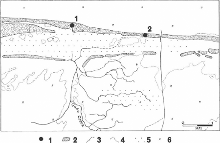
Fig. 2. Detailed map of the Barbakoeba area showing the location of settlement sites of the Barbakoeba complex and the situation of artificially raised field systems. Legend: (1) settlement sites of the Barbakoeba complex; (2) forested sand bars or cheniers; (3) rivers and creeks; (4) grass swamps and marshes; (5) complexes of ridged fields; (6) shrubs and marsh forest. Key to sites: (1) Barbakoeba Creek-2 (SUR-30); (2) Barbakoeba Creek-1 (SUR-29).
| |
| |
settlement sites of the Barbakoeba complex. These canals, measuring 4-8 m in width and 1.5 to 2 m in depth, may have functioned as fish ponds and means of communication across the marshes and swamps, connecting various cheniers. They are up to several kilometres in length and were occasionally taken as starting points for raised field systems (Boomert 1975).
| |
Pottery and stone artifacts
The present discussion is based mainly on the collections of Barbakoeba complex pottery made at the Parmarica Creek-1, Barbakoeba Creek-2 and Boekoe Creek-2 sites in 1961, 1964/1972, and 1975, respectively. Implements made of polished stone have been encountered only at Parmarica Creek-1. The ceramic material collected at the latter site and Barbakoeba Creek-2 amounts to in all about 500 potsherds of which 130 pieces could be identified according to vessel shape. The finds are kept in the Suriname Museum, Paramaribo. Manufacture and temper of the locally made earthenware is remarkably homogeneous, showing a preponderance of pounded potsherd temper, rarely accompanied by secondary inclusions of crushed shell, charcoal and/or quartz sand. As a rule, vessel walls are some 8-9 mm in thickness. All pottery was made by coiling and fired in the open air. Surfaces are moderately well smoothed. A few sherds in the Parmarica Creek-2 collection show perforations, applied after firing. They were obviously intended to repair cracks in the vessel walls.
Seven major Barbakoeba vessel shapes can be distinguished. Open bowls (Form 1) with direct or interiorly flattened rims, triangular in cross section, are most numerous, comprising 50.8% of the Parmarica Creek-1 and Barbakoeba Creek-2 potsherds which could be identified according to vessel shape (Figs 3, 8:1). In addition, bowls with restricted mouths (Form 3) are well represented, including 23.8% of the pieces (Fig. 4:2). Medium-sized jars with inflected contours of Form 2 (Fig. 4:1) are rare (0.8%). Necked jars, provided with direct or interiorly flattened rims, form an important Barbakoeba vessel category. Fragments of necked jars (Form 4) showing horizontal appliqué fillets on the neck or at the confluence between neck and belly (Figs 5:1-4, 10:4), are present in substantial numbers (13.1%). Bottles and jars of Form 5, lacking these features (Figs 5:5, 6:1-5), are less well represented (6.9%). Jars of Form 7, showing direct rims and typically convex necks, occasionally provided with horizontal appliqué fillets (Figs 7:1-2, 8:2), are rare (1.6%). Finally, a most interesting vessel category (Form 6) includes bowls showing exteriorly thickened rims with often flattened lips, intended to produce an elevated band adjacent to the lip of the vessel (Fig. 6:6-8). Only four pieces are known (3.1%).
In all 69 fragments of vessel bases were encountered (Figs 3:1,3, 7:3-5). They can be divided into circular (76.7%) and oval (4.3%) forms, both of which show unmodified (40.6%) or pedestalled (30.4%) junctions to the vessel walls. Annular bases (10.1%) occur only in association with circular base forms.
Sixty-one potsherds show some form of decoration. Horizontal, vertical or crescentshaped appliqué fillets (Figs 5:1-4, 6:1, etc.) are most numerous (24.6%). Rows of punctates (9.9%), nicks (11.5%) and fingertips (9.8%) occur either singly on vessel walls and rims (Figs 3:2-3, 10:3) or, more typically, in combination with appliqué fillets (Figs 5:2-4, 7:1, 10:4, 12:4). Red painting is rare (4.9%), as are sherds showing outwardbossed wall sections (1.6%). Lobed rims of various forms (Figs 10:6, 11:1,5) and vessel walls showing unerased coils (Fig. 10:9) are better represented (6.6% and 14.8%, re- | |
| |
spectively). Lobed rims are occasionally associated with geometric, anthropomorphic or zoomorphic head lugs (16.4%) of a particularly crude and highly characteristic style of modelling (Figs 8:3, 9:1, 11, 12:1-3). Some of these adornos consist of two identical, modelled-punctated biomorphic figures (Fig. 11:4-5).
Ceramic artifacts comprise pieces of cassava griddles, pestles, potstands, small discs, and zoomorphic or anthropomorphic figurines. The griddles measure 1.3 to 3.5 cm in thickness. The undersides of various specimens show the imprints of palm leaves or wickerwork (Fig. 9:3). Ceramic pestles are occasionally horned (Fig. 12:6) and may represent objects used for unidentified non-utilitarian purposes. The figurines obviously had similar functions (Figs 8:4-5, 9:1-2, 12:5). Interestingly, several figurines show legs with swollen calves, reminding of the formerly quite general practice of binding the legs in order to produce such swellings (Roth 1924: 447-448).
The polished stone implements include five unmodified, trapezoidal axes of my Form A1 (Boomert 1979), some of which were used secondarily as hammerstones, a notched axe of symmetrical, trapezoidal shape (Form C1a), an adze, a chisel, a rubbing stone, three fragments of grinding stones or metates, a whetstone, a hammerstone and, finally, some fragments of unidentifiable polished tools. The rock materials used comprise metabasalt, metadolerite, dolerite, granite, and laterite. The provenance areas of all of these rock types are to be found in the Precambrian basement area of Central East Suriname (see Boomert and Kroonenberg 1977).
Eight potsherds from Paramarica Creek-1 are definitely not locally made but represent ‘trade’ pieces, derived from one of the settlements of the Koriabo complex, i.e. the major cultural assemblage of the Guianas belonging to the Marajoaroid series or Polychrome Tradition of late-prehistoric to protohistoric times (e.g. Boomert 1986, Fig. 15). Apparently, the Amerindians of the Barbakoeba cultural tradition lived side by side with those of the Koriabo complex in Northeast Suriname for some time. The ‘trade’ sherds from Parmarica Creek-1 are tempered with quartz sand, micaceous quartz and caraipé, i.e. the ash of the siliceous bark of the kwepi or kauta tree (Licania apetala). They show scraped, modelled and white-slipped motifs, typically belonging to the Koriabo cultural heritage. Similarly, the Boekoe Creek-2 site yielded a Koriabo ‘trade’ piece, tempered with micaceous quartz sand. Moreover, particular Koriabo earthenware categories were apparently imitated by the Barbakoeba potters. This is suggested by the Form 6 bowls which undoubtedly represent copies of a specific Koriabo vessel type, a carinated bowl with everted lip (Boomert 1986, Fig. 12:7), which is widespread also in the various Amazonian pottery complexes belonging to the Polychrome Tradition (e.g. Hilbert 1968, Abb. 59; 6, 64: 1, 68: 2). In Brazilian Guiana it forms a major element of Early to Late Aristé (see Meggers and Evans 1957, Figs 42:4-5, 44:3, 45:2, etc.). Interestingly, the small collection made at the Oranje Creek/Cordonpad site yielded an identical Koriabo ‘trade’ piece.
All of this points to various forms of interaction, including e.g. relationships of intermarriage, trade and ceremonial exchange, between the Amerindians of the Barbakoeba complex and those of the Koriabo ceramic tradition in Northeast Suriname. This is suggested also by the fact that the particular Koriabo bowl found as a specimen of ‘trade’ pottery at the Barbakoeba Creek-2 and Oranje Creek/Cordonpad sites and imitated by the Barbakoeba potters as Barbakoeba Form 6, probably had non-utilitarian, ceremonial functions. Contacts between the Koriabo and
| |
| |
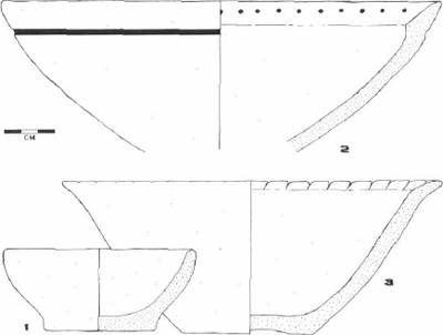
Fig. 3. Pottery of the Barbakoeba complex, Northeast Suriname. Provenience: 1, Parmarica Creek-1; 2-3, Barbakoeba Creek-2.
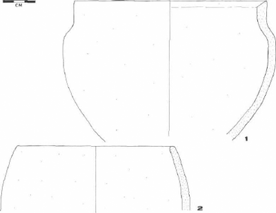
Fig. 4. Pottery of the Barbakoeba complex, Northeast Suriname. Provenience: 1, Barbakoeba Creek-2; 2, Paramarica Creek-1.
| |
| |
Barbakoeba Indians are suggested further by the presence of small quantities of Barbakoeba ‘trade’ sherds at sites of the Koriabo complex in Northeast Suriname. For instance, sherd-tempered pieces decorated with biomorphic adornos modelled in typically Barbakoeba fashion, are known from Peprepasi (SUR-34), a Koriabo settlement site to be found on a chenier ridge close to the Cottica Creek, a tributary of the Perica River. Finally, fragments of Barbakoeba Form 4 necked jars decorated with punctated appliqué fillets, have been found at another Koriabo settlement site in this same general area, Morico Creek (SUR-99). This site occupies part of a chenier ridge situated close to the Commewijne River. Charcoal from Morico Creek has been dated by radiocarbon to 455 ± 65 BP, i.e. about 455 years Before Present (GrN-2321), pointing to a date of about cal AD 1450 (Vogel and Waterbolk 1964). However, this date may refer to the final period of settlement at the Morico Creek site rather than to the episode during which its inhabitants interacted with the Barbakoeba Indians.
| |
Dating and cultural affiliations
According to criteria of both pottery style and radiocarbon dating, the Barbakoeba complex can be placed between cal AD 650 and 1250 (Fig. 13). The only radiocarbon date available for a Barbakoeba settlement site was obtained from charcoal, collected by Versteeg at a depth of 15-20 cm below the present surface in his testpit at Boekoe Creek-2 (Versteeg 1980). It yielded a C-14 measurement of 975 ± 50 BP (GrN-7936), suggesting a date of approximately cal AD 1050/1100. The episode of Barbakoeba interaction with the Koriabo communities of Northeast Suriname must be placed after about cal AD 900, i.e. the estimated time of inception of the Koriaban subseries, to which the Koriabo complex belongs, in the eastern portion of the Guianas. From here the Koriabo complex gradually expanded to the west, as far as the Northwest District of Guyana and, ultimately, the Windward Islands of the Lesser Antilles (Boomert 1977, 1986). By this time the separate existence of the Barbakoeba complex had come to an end. It can be suggested that the Barbakoeba cultural tradition disappeared due to assimilation to and finally incorporation of its Amerindians into Koriabo society. This conjecture is rendered unlikely, however, by the fact that no evidence is available suggesting that the pre-Columbian ridged fields of Northeast Suriname were cultivated after the close of Barbakoeba times.
The origins of the Barbakoeba complex are less difficult to establish. Together with a number of other prehistoric cultural assemblages of the coastal zone of Guyana, West to Central Suriname and West French Guiana, Barbakoeba can be taken to belong to the Arauquinoid series, the inception of which in this entire region is to be estimated at about cal AD 650/700. The origins of this major cultural tradition have to be sought on the middle reaches of the Orinoco River in Venezuela. By about cal AD 500 the Arauquinoid series expanded downriver, ultimately replacing the Barrancoid series on the Lower Orinoco. From here the Arauquinoid tradition moved into the Venezuelan coastal zone, Trinidad and the Guianas. The westernmost Arauquinoid complexes of the Guianas can be grouped into a Reposan subseries, called after the Mon Repos complex of Guyana. It comprises, from west to east, local traditions such as Mon Repos and Johanna, both of Coastal Guyana (Williams 1985: 70-72), and Early to Late Hertenrits in Northwest Suriname. Johanna and both Hertenrits complexes are associated with systems of
| |
| |
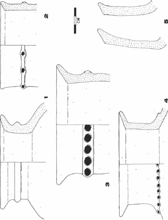
Fig. 5. Pottery of the Barbakoeba complex, Northeast Suriname. Provenience: 1, 3, Barbakoeba Creek-2; 2, 4-5, Parmarica Creek-1.
| |
| |
massive, artificially raised habitation mounds. The earliest of the Reposan assemblages show significant similarities with the local Arauquinoid complexes of the Lower Orinoco and Trinidad, notably Macapaima and Bontour. This suggests that the Arauquinoid expansion out of the Orinoco Valley took place in a relatively short time span (Boomert 1985, in press).
In the Suriname coastal zone the Reposan subseries gave rise to a number of local ceramic traditions which can be grouped into another subseries of the Arauquinoid series, Peruvian, called after the Peruvia complex of West Suriname. In addition to the latter cultural assemblage, the Peruvian subseries includes the Kwatta complex of the central portion of the Suriname coastal zone and Barbakoeba of its eastern part. The Crique Jacques complex of Northwest French Guiana appears to belong to this subseries as well. All of these local cultural traditions show pottery tempered with pounded potsherds (Boomert 1977). It should be noted that Peruvia has incorrectly been seen as part of the Hertenrits continuum (e.g. Versteeg 1985). Instead, numerous ceramic similarities indicate that the cultural affinities between Kwatta and Peruvia are much closer than those between the latter assemblage and both Hertenrits complexes. It is true that Peruvia pottery shows a number of generally Arauquinoid features, shared by most Reposan and Peruvian complexes, including both Hertenrits assemblages. However, more significantly, Peruvia earthenware incorporates strongly Kwattalike features such as multiple, horizontal rows of nicks or gashes parallel to the rim of wide-mouthed open bowls, bowls showing red-painted motifs, jars with concavo-convex, inflected contours, and bowls with lobed rims decorated with simple face designs (Tacoma et al. 1991, Fig. 12; Goethals 1953, Plates 6, 10; Versteeg 1985, Figs 37b-c, 38a, 39a, 40h).
A similar close affinity exists between Kwatta and Barbakoeba earthenware, pointing to frequent interaction among the Amerindians of the Peruvia, Kwatta and Barbakoeba complexes. The contemporaneity of these three local cultural traditions is shown also by the radiocarbon dates available for the Peruvian subseries. Two C-14 measurements are known for the type site of the Peruvia complex, Peruvia-2 (SUR-35), i.e. 1210 ± 30 BP (GrN-9361) and 755 ± 35 BP (GrN-9800), suggesting dates of about cal AD 800 and 1250, respectively (Versteeg 1980). These estimates and that for the Barbakoeba complex, noted above, compare favourably with the known radiocarbon measurements for the Tingiholo site (SUR-24) of the Kwatta complex, i.e. 1510 ± 50 BP (GrN-12,912), 1140 ± 90 BP (GrN-8250), 1050 ± 100 BP (GrN-8249), 1025 ± 50 BP (GrN-12,913), and 970 ± 50 BP (GrN-4552), indicating dates of approximately cal AD 550, 850, 950, 1000/1050, and 1050/1100 (Tacoma et al. 1991: 77; Versteeg 1980; Vogel and Lerman 1969). Unfortunately, radiocarbon dates are lacking for the easternmost situated Peruvian complex, Crique Jacques of Nortwest French Guiana (Cornette 1987, 1990; Rostain 1991: 16; Versteeg and Bubberman 1992: 60). A related cultural tradition, the Thémire complex, is known to have occupied the central coastal plain of French Guiana. It is characterized by pottery showing clearly Barbakoeba-derived elements as well as Koriabo and Early Aristé features (Barone Visigalli et al. 1991; Rostain 1992). Thémire can be included in a Thémiran subseries of the Araquinoid series which seems to exemplify a late-prehistoric to protohistoric process of cultural unification in the area between the Sinnamary River and the Ile de Cayenne, undoubtedly resulting from intensive interaction between the Arauquinoid and Marajoaroid communities in the region (Stéphen Rostain, personal
| |
| |
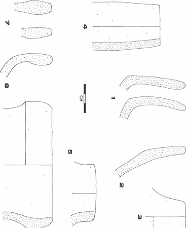
Fig. 6. Pottery of the Barbakoeba complex, Northeast Suriname. Provenience: 1-6, Parmarica Creek-1; 7-8, Barbakoeba Creek-2.
| |
| |
communication).
Analysis of the Kwatta complex pottery from the central portion of Suriname's coastal zone suggests that the forms of interaction, including ceremonial exchange and trade, shown between the Barbakoeba and Koriabo Indians, noted above, are duplicated by similar contacts between the Kwatta and Koriabo cultural traditions. Kwatta ‘trade’ pottery has been found at various sites of the Koriabo complex, including Onverdacht (SUR-4), Tambaredjo-3 (SUR-40), Morico Creek (SUR-99), Lelydorp-Van Hattemweg (SUR-106), and Commetewane Creek-1/2 (SUR-12/13). The reverse applies to Kwatta sites such as Tingiholo (SUR-24), Kwattaweg-km 8 (SUR-66), Kwatta-Derde Rijweg (SUR-23), Kwatta-Vierde Rijweg (SUR-22), and Kwatta-Garnizoenspad km 15½ (SUR-60). Interestingly, the Koriabo vessel shape found most frequently among these ‘trade’ pieces at Kwatta sites, is formed by carinated bowls showing exteriorly thickened rims with occasionally flattened lips, identical to the Koriabo vessels imitated by the Barbakoeba potters as Barbakoeba Form 6. The Kwatta specimens are often decorated with red- and/or white-painted horizontal zones on the concave upper part of the vessel. Temper includes quartz sand, micaceous quartz sand and caraipé. The widespread presence of especially this Koriabo vessel type at the sites of the Peruvian subseries strongly suggests that it had particular non-utilitarian functions such as offering cassava beer during ceremonial gatherings. Apparently it also formed a burial ware.
| |
Subsistence and social organization
Few data are known regarding the procurement strategies of the Amerindians of the Barbakoeba complex. It can be conjectured, however, that, just as the other peoples of the Peruvian subseries, the Barbakoeba Indians combined horticulture with small game hunting of animals and birds, fishing and the unspecialized collecting of wild plant foods, small reptiles, amphibians and insects (see e.g. Boomert 1980; Versteeg 1985). Rather than practising shifting (swidden) cultivation as the present Amerindians of the Guianas, the Barbakoeba people grew their main crops on vast areas of artificially raised clay beds, constructed close to their settlements. In the Guianas this type of ridged-field cultivation appears to represent a subsistence strategy characteristic of mainly the cultural complexes belonging to the Arauquinoid series, although in Northwest Suriname its inception may date back to Buckleburg times. At any rate, extensive systems of ridged fields are known to be associated with both Hertenrits complexes (Boomert 1980), Peruvia (Versteeg 1985), Barbakoeba and, in coastal French Guiana, the Thémiran subseries (Rostain 1991, 1992). The fact that artificially raised fields are unknown from the central portion of Suriname's coastal plain cannot be taken as definite proof that the Kwatta Indians did not practise ridgedfield cultivation. Indeed, it is possible that these raised clay beds were leveled due to the dense settlement of this region in colonial times and its intensive cultivation which from the seventeenth century onwards involved the reclamation of large areas of marsh and swamp for monocropping.
It is quite obvious that, like elsewhere in the tropical lowlands of South America, improvement of the poor drainage conditions of the seasonally or permanently inundated marsh and swamp soils of the eastern part of Suriname's coastal plain constituted one of the major functions of the Barbakoeba raised beds. By channeling overflow water into the back swamps,
| |
| |
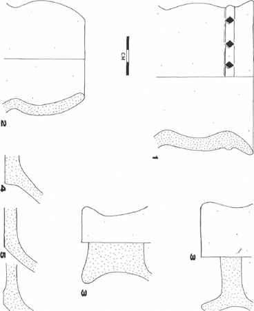
Fig. 7. Pottery of the Barbakoeba complex, Northeast Suriname. Provenience: 1, Barbakoeba Creek-2; 2-5, Parmarica Creek-2.
| |
| |
ditches and earth constructions allowed the cultivation of upland and dryland crops in areas where this would not have been possible otherwise. The presence of pottery griddles at the sites of the Barbakoeba complex indicates that bitter cassava was one of the root crops grown on the raised beds of the area. The fact that these sites yielded fragments of grinding stones or metates, cannot be taken as sufficient evidence for the cultivation of maize as they may have been used for the processing of root crops as well. However, it has been noted that raised beds such as those of the Barbakoeba area are suited especially to crops, including maize, which have a long growing season and are susceptible to rotting when too much moisture is present. The ditches drained the subsoil of the fields, served as reservoirs in the dry season and may simultaneously have functioned as fish ponds. Fertility of the ridge soils was obviously continually being enhanced through pulverization and the concentration of organic matter from the ditches on the fields. Clearly, as a system designed to reclaim extended areas of marginal land for purposes of cultivation, ridged-field horticulture can be judged only as highly successful (e.g. Denevan 1982; Turner II & Denevan, 1985).
One reason for the intensified exploitation of the coastal marsh-and-swamp plain of the Guianas, shown by the construction of the vast areas of ridged fields, may have been the region's rich protein resources in the form of animals and fish. Analysis of human skeletal remains encountered at the Tingiholo site of the Kwatta complex, has shown the high incidence of regular patterns of Harris' lines, i.e. growth-arrest-lines which develop in long bones during linear growth due to temporary conditions of disease or starvation. It has been suggested that the Kwatta Indians were susceptible to yearly protein deficiencies at the height of the wet season when flooding had caused especially the fish fauna to disperse (Khudabux 1991a: 54-55, 58-59, 1991b; Khudabux & Bruintjes 1988; Khudabux et al. 1991; Tacoma et al. 1991: 89-97). The construction of canals or fish ponds such as found in the Barbakoeba area, can be seen as an adaptive response to overcome this seasonal dietary shortage. Finally, the question remains why many beds in especially the eastern part of the Suriname coastal zone were raised as high as 150 cm, i.e. well beyond the present rainy season swamp level. A possible explanation would be that during Barbakoeba times climatic conditions were more humid than at present, resulting in formerly much higher levels of wet season effluent water. This is confirmed by palynological investigations in the Amazon Basin indicating that extremely wet circumstances prevailed throughout the tropical lowlands of South America in the episode between cal AD 700 and 1250 (Colinvaux et al. 1985).
The labour involved in the construction of the complexes of raised beds must have been considerable, pointing to a truly substantial manpower and relatively high population density in the area. It can be suggested that in the coastal zone of the Guianas the onset of the wet climatic conditions, noted above, formed the main cause inducing the construction of the ridged-field systems. However, it is equally possible that demographic reasons were responsible, i.e. that the demand of reclaiming marginal land arose when the carrying capacity of the naturally-formed chenier ridges and stream levees, where horticulture was practised originally, had fallen below the need of domesticated plant foods due to a growing population. This would have necessitated the reclamation of marginal lands adjacent to the cheniers and stream levees which formed the centres of habitation. Such a demographic explanation is supported by
| |
| |
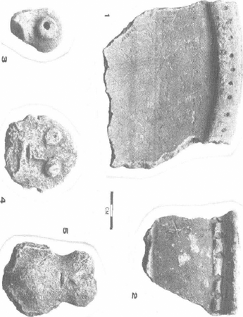
Fig. 8. Pottery of the Barbakoeba complex, Northeast Suriname. Provenience: 1-3,5, Parmarica Creek-1; 4, Barbakoeba Creek-2.
| |
| |
ethnohistorical research which has shown that, induced by population pressure, the Arawakan-speaking Palikur Indians constructed artificially raised beds for cassave cultivation in the marsh-and-swamp plain of Brazilian Guiana as late as the seventeenth century (Grenand 1981). Apparently, alternative forms of cultivation requiring less inputs could not adequately sustain the demand levels. Finally, construction and maintenance of the artificial earth works required high-level management decisions and coordination, inevitably leading to new means of social integration and the formation of a permanent, centralized decision-making authority in the communities involved. As such the ridged-field systems and the artificial mound complexes of Hertenrits type are indicative of a growing complexity of Amerindian society, eventually resulting in the rise of chiefdoms in the mainland areas of the Caribbean.
The former existence in the South American tropical lowlands of locally dense populations with sufficient subsistence resources to support complex ranked societies, has long been minimized. Recent ethnohistorical and archaeological research has made it abundantly clear, however, that during lateprehistoric times such chiefdoms occupied substantial portions of the tropical lowlands, notably the flood plains of the major river systems of the continent, its coastal regions and wet savannas. As these chiefdom societies were the first to be destroyed in early colonial times, scholars have long believed erroneously that the tribally organized, horticultural communities of the Amazonian interfluves typified pre-Columbian Amerindian society. In contrast to the latter, the contact-period chiefdoms of the Amazon and Orinoco drainages generally occupied extensive domains inhabited by dense, fully sedentary populations, concentrated in towns of at least of few thousand inhabitants and ruled by hereditary chiefs, claiming divine origin. Intensive land-use and food-producing systems, elaborate storage facilities for surplus goods, trade networks and markets characterized economy and subsistence of these riverine chiefdoms. Professional priests or specialist diviners, temple structures and ancestor worship distinguished their religious organization from that of the past and present tribal horticulturalists (e.g. Roosevelt 1987).
There cannot be much doubt that Reposan complexes such as Johanna and Early to Late Hertenrits formed cultural traditions of prehistoric Amerindian peoples with a social organization on chiefdom level. The Hertenrits site apparently formed the sociopolitical centre of a series of artificial habitation mounds. It is connected with these subsidiary mounds by a number of seasonally inundated pathways which run radially from the main settlement into the marsh. The height of all mounds, well beyond that of former or present swamp level, indicates that they were raised for reasons other than just the obtaining of all-year dry occupation floors. The total amount of clay, used in the building of the Hertenrits mound, has been estimated at not less than about 100,000 cubic metres. To this the in all 160 hectares of artificially raised clay beds can be added which are to be found in the immediate surroundings of the Hertenrits site (Boomert, 1980). In view of this enormous amount of earth work, it is understandable that some scholars have argued that chiefdom-type societies such as those of Johanna and Hertenrits arose in response of the need of central organization and management of enterprises of construction and maintenance of this kind. However, others favour a more competitive theory, stressing conflict and competition among kinship groups for the control of the intensively exploitable and strategically controllable basic subsistence resources such as
| |
| |
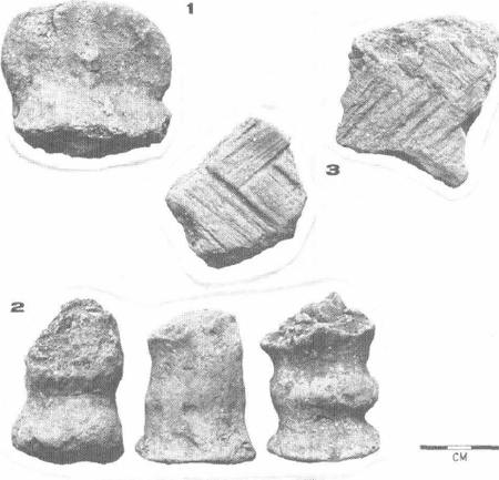
Fig. 9. Pottery of the Barbakoeba complex, Northeast Suriname. Provenience: 1-3, Parmarica Creek-1.
| |
| |
ridged-field systems.
The absence of artificially raised habitation mounds in the coastal zone of Suriname, east of Hertenrits, and that of West French Guiana suggests that the extent of the naturally-formed chenier ridges of this region was sufficient to provide ample space for habitation to the indigenous populations. Consequently, it is less likely that the sociopolitical organization of the peoples of the Peruvian subseries was as complex as that of mound societies such as Early to Late Hertenrits and Johanna. Cultural norms administering archaeologically identifiable, status-specific behaviour such as burial rites, appear to be quite similar among all Arauquinoid peoples in the Guianas. Unfortunately, no data regarding the mortuary customs of the Barbakoeba people are available. However, a comparison of the Kwatta and Early to Late Hertenrits burial traditions suggests a close uniformity between both cultures as regards to treatment of the dead (see e.g. Boomert 1977, 1980; Tacoma et al. 1991; Versteeg 1985). Consequently, although no evidence is available to suggest that the Kwatta, Barbakoeba and Crique Jacques peoples had reached a degree of societal complexity as high as that of the Reposan communities in the western portion of the coastal zone of the Guianas, the possibility remains that they had moved beyond the tribal level of sociopolitical integration.
| |
Literature
Barone Visigalli, E., M.T. Prost and Stéphen Rostain, 1991
Modalités d'occupation des sites Amerindiens cotiers en Guyana: Le cas de La Sablière, Kourou. Direction des Antiquités, Cayenne. |
Boomert, Arie, 1975
Pre-Columbian raised fields in Coastal Surinam. Proceedings of the Sixth International Congress for the Study of Pre-Columbian cultures of the Lesser Antilles, Guadeloupe 1975: 134-144. Centre Universitaire Antilles Guyane, U.E.R. Lettres 197, Guadeloupe. |
Boomert, Arie, 1977
Prehistorie. In: C.F.A. Bruijning, J. Voorhoeve and W. Gordijn, eds, Encyclopedie van Suriname: 515-517. Amsterdam/Brussel: Elsevier. |
Boomert, Arie, 1978
Prehistoric habitation mounds in the Canje River area? Archaeology and Anthropology: Journal of the Walter Roth Museum of Archaeology and Anthropology 1 (1): 44-51. |
Boomert, Arie, 1979
The prehistoric stone axes of the Guianas: A typological classification. Archaeology and Anthropology: Journal of the Walter Roth Museum of Archaeology and Anthropology 2 (2): 99-124. |
Boomert, Arie, 1980
Hertenrits: An Arauquinoid complex in North West Suriname (Part I). Archaeology and Anthropology: Journal of the Walter Roth Museum of Archaeology and Anthropology 3 (2): 68-103. |
Boomert, Arie, 1985
The Guayabitoid and Mayoid series: Amerindian culture history in Trinidad during late prehistoric and protohistoric times. Proceedings of the Tenth International Congress for the Study of the Pre-Columbian Cultures of the Lesser Antilles, Martinique 1983: 92-148. Centre de Recherches Caraïbes, Université de Montréal, Montréal. |
Boomert, Arie, 1986
The Cayo complex of St. Vincent: Ethnohistorical and archaeological aspects of the Island Carib problem. Antropológica 66: 3-68. |
Boomert, Arie (in press)
Agricultural societies in the continental Caribbean. In: Jalil S. Badillo and Arie Boomert, eds., The autochthonous societies. UNESCO General History of the Caribbean. Vol. 1. Paris. |
| |
| |
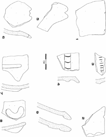
Fig. 10. Pottery of the Barbakoeba complex, Northeast Suriname. Provenience: 1-8, Parmarica Creek-1; 9, Barbakoeba Creek-2.
| |
| |
Boomert, Arie, and Salomon B. Kroonenberg. 1977
Manufacture and trade of stone artifacts in prehistoric Surinam. In: B.L. van Beek, R.W. Brandt and W. Groenman-Van Waateringe. eds, Ex Horreo: IPP 1951-1976: 9-46. Cingvla 4, University of Amsterdam, Amsterdam. |
Bubberman, Frans C., 1975
In het spoor van de Marrons. Mededelingen Stichting Surinaams Museum 17/18: 24-27. |
Bubberman, Frans C., 1977
Prehistorische landbouw. In: C.F.A. Bruijning, J. Voorhoeve and W. Gordijn, eds, Encyclopedie van Suriname: 515-517. Amsterdam/Brussel: Elsevier. |
Colinvaux, Paul A., M.C. Miller, Kam-biu Liu, M. Steinitz-Kannou and I. Frost, 1985
Discovery of permanent Amazon lakes and hydraulic disturbance in the Upper Amazon Basin. Nature 313: 42-45. |
Cornette, Alain, 1987
Quelques données sur l'occupation amérindienne dans la région Basse Mana-Bas Maroni, d'après les sources ethno-archéologiques. Equinoxe 11 (24): 70-99. |
Cornette, Alain, 1990
La céramique Amérindienne de Guyana. Proceedings of the Eleventh Congress of the International Association for Caribbean Archaeology. Puerto Rico 1985: 196-213. Fundación Arqueológica, Antropológica e Histórica de Puerto Rico: Universidad de Puerto Rico/United States Forest Service. |
Denevan, William M., 1982
Hydraulic agriculture in the American tropics: Forms, measures, and recent research. In: Kent V. Flannery, ed., Maya subsistence: Studies in memory of Dennis E. Puleston: 181-203. New York: Academic Press. |
Goethals, Peter R., 1953
An archaeological reconnaissance of Coastal Suriname. Yale University, New Haven (typescript). |
Grenand, Pierre, 1981
Agriculture sur brûlis et changements culturels: Le cas des Indiens Wayãpi et Palikur de Guyane. Journal d'Agriculture Traditionelle et de Botanique Appliquée 31 (1/2): 43-70. |
Hilbert, Peter Paul, 1968
Archäologische Untersuchungen am Mittleren Amazonas: Beiträge zur Vorgeschichte des südamerikanischen Tieflandes. Marburger Studien zur Völkerkunde 1. Berlin: Reimer. |
Janssen, Joost J., 1974
Wanekreek: Indiaanse landbouwbedjes (‘raised fields’). Paramaribo (typescript). |
Khudabux, Mohamed R., 1991a
Effects of life conditions on the health of a negro slave community in Suriname. 's-Gravenhage: Pasman. |
Khudabux, Mohamed R., 1991b
Physical anthropological investigations of pre-Columbian skeletal remains from the ‘Tingi holo ridge’ in Suriname (S.A.). Proceedings of the Thirteenth International Congress for Caribbean Archaeology, Curaçao 1991. II: 813-831. Reports of the Archaeological-Anthropological Institute of the Netherlands Antilles 9, Willemstad. |
Khudabux, Mohamed R., and Tj.D. Bruintjes, 1988
De Kwatta Indianen: Vroege bewoners van Suriname. Natuur en Techniek 56 (2): 110-119. |
Khudabux, Mohamed R., G.J.R. Maat and Aad H. Versteeg, 1991
The remains of prehistoric Amerindians of the ‘Tingi holo ridge’ in Suriname: A physical anthropological investigation of the ‘Versteeg collection’. Proceedings of the Twelfth Congress of the International Association for Caribbean Archaeology, Cayenne 1987: 135-151. Association Internationale d'Archéologie de la Caraïbe, Martinique. |
Meggers, Betty J., and Clifford Evans, 1957
Archeological investigations at the mouth of the Amazon. Smithsonian Institution, Bureau of American Ethnology, Bulletin 167. Washington, D.C. |
Roosevelt, Anna C., 1987
Chiefdoms in the Amazon and Orinoco. In: Robert D. Drennan and Carlos A. Uribe, eds, Chiefdoms in the Americas: 153-184. Lanham: University Press of America. |
Rostain, Stéphen, 1991
Les champs surélevés Amérindiens de la Guyane. Centre ORSTOM de Cayenne. Université de Paris-I, Cayenne. |
| |
| |
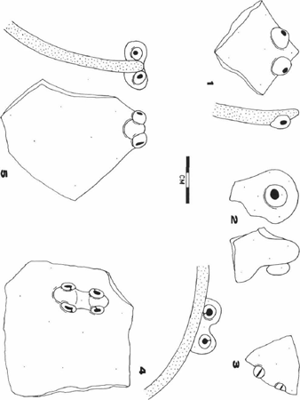
Fig. 11. Pottery of the Barbakoeba complex, Northeast Suriname. Provenience: 1-5, Parmarica Creek-1.
| |
| |
Rostain, Stéphen, 1992
La mise en culture des marécages littoraux de Guyane à la période précolombienne récente. Centre ORSTOM de Cayenne, Cayenne. |
Roth, Walter E., 1924
An introductory study of the arts, crafts, and customs of the Guiana Indians. Thirty-Eighth Annual Report of the United States Bureau of American Ethnology, 1916-17, Smithsonian Institution, Washington, D.C. |
Tacoma, Jouke, Dirk C. Geijskes, G.J.R. Maat and G.N. van Vark
(1991) On ‘Amazonidi’: Precolumbian skeletal remains and associated archaeology from Suriname. Publications Foundation for Scientific Research in the Caribbean Region 127, Amsterdam. |
Turner II. B.L., and William M. Denevan, 1985
Prehistoric manipulation of wetlands in the Americas: A raised field perspective. In: I.S. Farrington, ed., Prehistoric intensive agriculture in the tropics, I: 11-30. BAR International Series 232. Oxford: British Archaeological Reports. |
Versteeg, Aad H., 1980
C-14 datings from archaeological sites in Suriname. Mededelingen Stichting Surinaams Museum 32: 38-56. |
Versteeg, Aad H., 1985
The prehistory of the Young Coastal Plain of West Suriname. Berichten van de Rijksdienst voor het Oudheidkundig Bodemonderzoek 35: 653-750. |
Versteeg, Aad H., and Frans C. Bubberman, 1992
Suriname before Columbus. Mededelingen Stichting Surinaams Museum 49A, Paramaribo. |
Vogel, J.C., and J.C. Lerman, 1969
Groningen radiocarbon dates VIII. Radiocarbon 11: 351-390. |
Vogel, J.C., and H.T. Waterbolk, 1964
Groningen radiocarbon dates V. Radiocarbon 6: 349-369. |
Williams, Denis, 1985
Ancient Guyana. Georgetown: Ministry of Education, Social Development and Culture. |
Arie Boomert (1946) studied cultural anthropology and prehistoric archaeology at the University of Amsterdam. He worked as an archaeologist successively at the Surinaams Museum, Paramaribo, and the Department of History, the University of the West Indies, St. Augustine, Trinidad. His research interests encompass the archaeology and ethnohistory of the South American tropical lowlands and the Caribbean.
| |
| |
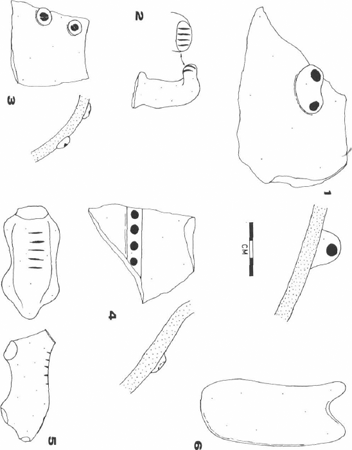
Fig. 12. Pottery of the Barbakoeba complex, Northeast Suriname. Provenience: 1, 4, Barbakoeba Creek-2; 2-3, 5-6, Parmarica Creek-1.
| |
| |
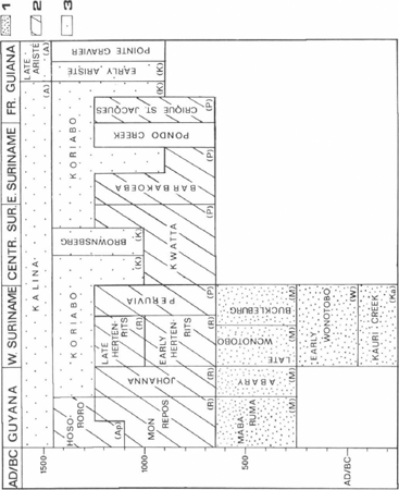
Fig. 13. Chronological chart of the Ceramic Age in the northern part of the Guianas. Legend: (1) Saladoid series; (2) Arauquinoid series; (3) Marajoaroid series. Abbreviations Saladoid subseries: Ka, Kaurian; W, Wonotoban; M, Mabaruman. Abbreviations Arauquinoid subseries: R, Reposan; P, Peruvian; Ap, Apostaderan. Abbreviations Marajoaroid subseries: K, Koriaban; Ar, Aristan.
|
|